
In July of 2018, the Octopus Foundation will head to the Island of Mozambique, on the South-Eastern coast of the African continent. Loaded with its underwater cameras, drones, sonars, sailing and diving skills, the crew will document and map out several ancient shipwrecks that are lying at the bottom of the sea. 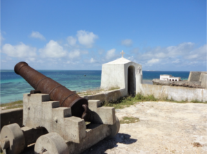
Brief history
Some time during the 15th century, the Island of Mozambique became a highly strategic location for commercial vessels on their perilous journey from Europe to India. Its ideal location turned out to be an important source of tension, conflict and rivalry between some of the most powerful maritime empires of the world. The tiny territory was Mozambique’s first capital, until the Portuguese moved it to Maputo. Through the centuries, the inhabitants built vastly diverse buildings, which have become historical vestiges. In the surrounding sea, dozens of shipwrecks can be found on the seafloor. This unprotected abundance attracted treasure hunters, who have been looting the priceless vestiges for the past 20 years.
International project
Fortunately, the dedicated work of Dr Ricardo Duarte, local archaeology professor, was successful in convincing the authorities to evict the looters from the country. He also realised the inventory of the many shipwrecks in the area. Today, these submerged pieces of history are to be studied at the upcoming local center for underwater archeology – the very first of its kind to be launched in Mozambique. The center will be sponsored by the Mozambique’s Ministry of Culture, as well as the Eduardo Mondlane University of Maputo, and the UNESCO. In the near future, the local public and foreign visitors will be able to witness the fascinating archaeological work in a museum to be built.
The Octopus Foundation’s role in Mozambique
Once on the island, Julien Pfyffer and his team will provide the local archaeologists with all of their tools and specialised skills. The Foundation will:
- Take high quality photos and draw sketches in order to reconstitute the history behind some of the wrecks.
- Use its aerial drones to detect and register the exact location of sunken shipwrecks and various objects that lie on the seafloor in shallow waters. These precise waypoints will help further expeditions.
- Use its underwater drones to safely approach submerged structures before sending divers and archaeologists. These diving tools will also help in creating photogrammetry tools and 3D computer models of interesting underwater sites, as well as taking pictures in great depths or harder to reach places.
- Publish bathymetric maps with the help of a sailing boat’s sonar, in order to measure the depth and the topography of the seafloor.
- Create 3D computer models of shipwrecks, allowing scientists and the greater public to wander around the sunken vestiges. For these digital dives, there is no need of diving knowledge and there is no risk of damaging the site.
- Produce an orthophotoplan of the zone, which is a vertical projection of the relief on a horizontal plan. It is a highly precise tool that allows to study a subject with a precision down to a centimetre. With air tanks, a diver has very limited time to work underwater. By taking the site out of the water, the study zone can be inspected for as long as it takes. It is a system that is used by Google Maps.
All of these tools will allow the documentation and the digital mapping of some of the shipwrecks that are dispersed in the waters surrounding the Island of Mozambique. The careful work will help to better understand the incredibly rich history that unfolded in this particular area. The tasks realised by the Octopus Foundation, such as the creation of a panel of media, will provide the scientists with subjects of study. They will shed a little light on the amazing underwater discoveries.
To learn more about the Octopus Foundation’s mission to Mozambique